Sunrise from the Gan anchorage
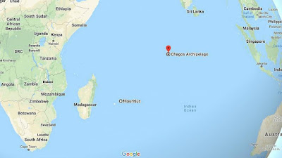
After almost 3 months in the Maldives we are getting ready to leave for Chagos. As you can see Chagos is a dot in the middle of the Indian Ocean. It is most famous for the island of Diego Gracia, the only inhabited island in the chain and the home of a large, US military base. We are not allowed anywhere near Diego Garcia, but we can stop at two of the remote atolls in the Chagos archipelago.
Chagos, aka British Indian Ocean Territory (BIOT), is controversial due to some of the operations on Diego Gracia, like CIA rendition flights, as well as how the British ended up with the island. The Brits separated Chagos from Mauritius when they were reorganizing some of their colonies to give self-rule to the Seychelles and Mauritius. The locals living in Chagos were moved to the Seychelles and Mauritius. The US got a long term lease for the base and Brits got a great deal on two nuclear submarines.
The UN and International Court of Justice has recently upheld the Mauritanian's rights to the islands. But the Brits are not buying the story. Either way, the area is patrolled by the British Overseas Indian Ocean Territory vessels. You have to jump through a lot of hoops to get permission to stop in Chagos while transiting the Indian Ocean. Vessel insurance, evacuation insurance, wreck removal insurance, etc. During Covid season they only allow three boats at a time. There are no communications there, ie no cell towers, no people and no Costco.
We plan to be in Chagos for a few weeks and then do 10-12 day passage to the Seychelles. I'll try to post some on passage-- short blogs while we are on our way to Seychelles.
_________________
The view of Feydho on the right, the causeway that connects Gan and Feydho in the foreground and the end of the long Gan airport runway in the background. Taken from our masthead while anchored in the Gan anchorage.
A few weather shots. A rainbow fighting to get out of this cloud.
Yet another squall heading our way.
A couple of live, 3.5 inch Cowries on the reef.
Lot of turtles in Gan, very tame
________________________________________
Cruisers Notes
Gan anchorage
Outside cut: 00*41.0S, 073*08.75E
The cut into the Gan anchorage lies between Gan and Feydhoo islands and is in front of the causeway connecting these islands. The cut is not as apparent as the typical cuts further north and the water is often not clear.
There is a starboard side pole that marks the outer portion of the cut.
There is a starboard side inner pole on the inside of the cut that is not visible at higher tides.
The cut has about 10 feet minimum at low tide.
On the inner, starboard side of the cut is a shallow spot that sticks into the cut. It is often not very visible due to the water clarity. When you get toward the inside of the cut, stay a bit clear of the starboard side ( a little closer to the breakwater wall on your port). You can turn to starboard into the main portion of the anchorage once you have passed the steps that are in the breakwater wall to port.
Directly ahead of the cut as you enter is an open area with no moorings. This is in front of the tied off to the wall Coast Guard and Police boats. We were told we are not allowed to anchor in this area.
The anchorage is very tight, with the reef to the east and the existing local boats on moorings. These moorings are continually used, so don't expect an empty one to stay empty. The holding varies from good sand to somewhat scoured rubble. The scoured portions are where the current flows under the causeway.
You can't put out much scope as the winds come from all directions. The anchorage depths range from about 6 feet to 15feet. The anchorage is often rolly at high tide.
Petrol and diesel are available in the Feydho harbour. Take the dinghy 5 minutes to the harbour and head to the back wall where the petrol station is to fill your jerry jugs.
Provioning - there are 3 decent grocery stores within walking distance. The 3S store i just across the street and a little south of the petrol station. Its the best place o get eggs as they use a bright flashlight(torch) to check them before they put them in your container.
We are currently anchored at 00*41.136S, 073*08.608E
_____________________________________________________________
WEATHER UPDATE
We've decided to sit tight for a bit. The two main weather models that we use for looking at passage weather are in wild disagreement with each other. The Euro model is fairly benign where we are headed, but shows the start of an RTS, Revolving Tropical Storm, aka cyclone, in the northern hemisphere way north of us. The GFS model shows a much larger RTS in the northern hemisphere, coming much closer to the Maldives. It also forecasts a matching RTS in the southern hemisphere coming close to where we want to go, Chagos. Normally the models don't differ this much, so we need to wait long enough for their little disagreements to resolve.
Euro mode. We are located near the label just below the middle in the blue section. Chagos is at the bottom, center
GFS model
Paul


No comments:
Post a Comment