Showing posts with label Fiji Enroute. Show all posts

Wednesday, June 7, 2017

Fiji Off the Docks

VudaIMG_6862
We’ve finally had enough time in Fiji to get out of passage mode. The passage from New Zealand to Fiji wasn’t one of my favorites. The rhumb line distance(shortest distance between points) is about 1,040 nautical miles. The course we laid out to take took us further east so that we could be better prepared for any northerly winds as we approached Fiji. That distance was about 1,080nm. The actual distance we travelled through the water 1,204nm.
I think the reason I didn’t like the passage – besides the early rolly conditions – was a little burn out. Before a passage I always get pretty psyched to go. Watching the weather every day looking for good exit timing, checking conditions for boats that have already left, getting meals ready, getting the boat ready for offshore, figuring out customs exit and entrance issues… On this passage we waited over 3 weeks trying to get a decent weather window to leave. Just too long for me.
swivelIMG_6821
Here’s the damage from getting our anchor stuck in the underwater junk in the port of Laukota where we first landed and attempted to clear in. The tabs on the right hand side where the swivel connects to the are anchor clearly bent.
LautokaIMG_6811
The view entering the port of Lautoka. It reminds me of a Mosquito Coast Central American portscape. (click to biggerate)
VudaIMG_6826
Once we got into Vuda (pronounced Bunda) Point Marina and had cleared into Fiji (at least partially), I found one of the local metal workers who had a side-grinder with a cut-off wheel to cut the distorted, brand new, stainless steel swivel off the anchor. This exercise reminded me of the definition of racing sailboats: standing in a cold shower while burning hundred dollar bills.
VudaIMG_6829
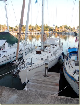
Vuda Point is an oddball marina. It uses Med-moor style mooring, but you go into the slip bow-in. This way you won’t hit your rudder on the sloping quay wall. The little wood platform you see in this picture is where you clamber over the bow pulpit and leap each time you want to leave the boat. Leaving at low-tide requires a different set of skills than the high-tide exoduses.
VudaIMG_6831
The other strange thing about Vuda Marina is they store boats in holes. They dig large holes in the ground to drop boat’s keel into. Then set the boats on old tires. This is for storage during the cyclone season.
VudaIMG_6917
Getting on land requires stopping for lunch at a local’s stop. This one was highly recommended by our cab driver. Here’s Chris and crewmate Bill enjoying curry and large helpings of some kind of Indian-style rice.
MamanucaIMG_6929
We finally broke free of the hot and cockroach infested marina and headed out to the Mamanuca Islands about 12 miles offshore. We have a duck mascot who has lived on our transmission since we rescued him in the Ha’pai group in Tonga a few years ago. He apparently had had enough and decided to make a break for it. Using his plastic beak he chewed threw the leash we had him on and sailed away. I jumped in the dinghy and did a forced return to his perch.
venilevuP6050088
Getting out to the islands meant we could get back into the 85*F water.
VenuiLevuP6020064
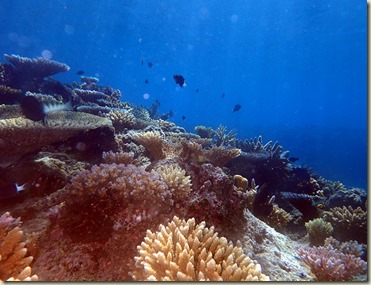
Some nice coral scapes
VenuLevuP6010046
Along with a fair share of little fishes
VenuLevuP6010038
This is a tiny, pencil thin, pipe fish of some variety.
venulevuP6050078
Little blue fish
VudaIMG_6919
Many of you grew up with your parents telling you stories, in a effort to get you interested in nature, of how coconuts floated across thousands of miles of open ocean, only to land on small deserted islands and generate new coconut groves on those islands. Similar to the myths parents tell their young children today about global warming. The coconut story has been definitively debunked. Here you can see this tug towing a large barge overflowing with full-sized coconut trees destined for the out islands. Kind of the modern Johnny-Appleseed of the South Pacific.
VudaIMG_6889
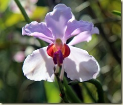
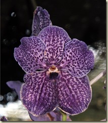
While still on the mainland we did a tour of the botanical gardens. I’ll finish off this blog with soft music playing and a display of orchid diversity.
VudaIMG_6843VudaIMG_6872VudaIMG_6873VudaIMG_6895VudaIMG_6904VudaIMG_6912
Paul

Saturday, May 27, 2017

Fiji Arrived - Sort Of

17* 41.204S 177* 22.865E

After our 3 hours of rain we motored for 20 hours. Then about midnight the winds decided to be kind and picked up enough to sail and be from enough of the East to allow us to make our course. We watched the sun rise over Fiji as we approached the Nuval Passage, the entrance cut through the reef. It was a beautiful clear blue sky, we only had a tiny swell running. Since it was Sunday here, we were not allowed to go to the Vuda Point Marina to check-in and had to continue on to the port of Lautoka.
Port Control had us anchor just off the wharf in 12 feet or so. After awhile they came back to us and said that no one was available from Customs. They gave me permission to go to the quarantine buoy just outside Vuda Pt Marina. I said fine and off we went --- Not!
Our anchor had gotten caught in the underwater junk yard in front of the wharf. I free-dove the anchor a bunch of times but could not get the sea to let it loose. Tried tying a line to the forward end of the anchor and pulling with the dinghy. No joy. Finally got out the Hooka (underwater air breathing device) and sat on the bottom in the foot thick mud and worked on the problem. I ended up digging a passage behind the anchor (away from the boat side) and then bracing my feet on the large pipe that held the anchor solid to the sea floor and yanked the anchor stem back and forth. I finally got the point free and raced to the surface to have Bill haul in the chain before it got stuck again. Inspecting the anchor afterward I found my almost brand new anchor swivel to be bent.

The good thing is that it is 80*F air temp, 84*F water temp and sunny.


----------
radio email processed by SailMail
for information see: http://www.sailmail.com

Friday, May 26, 2017

En Zed to Fiji

19* 54S 176* 52E 005*T 6.9kts

We are down to motoring now with a very light south wind. We had 3 or 4 hours of heavy rain starting around 4am. Heavy enough that it found a new leak in the instrument panel above the companionway that flows down hill to the galley -- argh!! It looks like one of those leaks that is physically impossible.
We are about 125 miles from the reef pass to enter Fiji. At this rate expect to get in tomorrow morning (Sunday).
This is going to turn out to be either one of those trips that you remember, or maybe one of those trips that you forget.


----------
radio email processed by SailMail
for information see: http://www.sailmail.com

Thursday, May 25, 2017

En Zed to Fiji

21* 14S 176* 48E 325*T 7.0

Spoke a little too soon about when we might be getting in. The winds decided to take a turn to directly out of the north -- the direction we need to go. Guess we should have put in more easterly earlier in the trip when we could. Now we are stuck tacking toward Fiji about 200 miles out. Maybe late on Sunday we'll make it in. The conditions are pretty mellow now with small seas and 14kts of wind. Hot, humid and overcast. Haven't checked the water temperature yet, but I bet it is legal for snorkeling.


----------
radio email processed by SailMail
for information see: http://www.sailmail.com

Wednesday, May 24, 2017

En Zed to Fiji

23* 23*, 177* 34E, 353*T, 7kts
Making good time. Last night it was a beam reach doing 7-8kts all night. Bill, our trusty San Fran crew, woke me up at midnight to do my 12 to 3am watch with "Rudolph, its your turn to drive the sleigh." We are about 300 miles out of Fiji and should arrive late Sat or Sun (local time, its Thursday here now).

Pauk


----------
radio email processed by SailMail
for information see: http://www.sailmail.com

Tuesday, May 23, 2017

En Zed to Fiji

26* 21S, 177*21E, 011*T 6.6kts
We're well on our way to Fiji. Left the Bay of Islands after easily clearing customs about 4 days ago. Its been a bumpy, rolly trip so far -- haven't felt much like sitting at the nav station and trying to write a blog post. We even hove-to for the night a few nights ago. Mainly to slow down to allow the bad weather ahead near Fiji to work it self east and south. (Heaving-to, or technically in our case fore-reaching, is when you reduce sail and point the boat just off the wind. The motion gets reasonably nice and the boat stays fairly closely to its original position).

Had an interesting CF reefing event the other day when two of the reeflines bowlines magically untied themselves. Who tied those knots!!! We've spent a lot of this trip with 2 reefs in the main and small staysail. Hope to be turning off a bit maybe tomorrow and get a faster more comfy ride.

It was really cold the first two nights out. A real effort to just get dressed for your watch. Its now gotten a lot warmer -- need to dig out a my shorts. We should be into Vuda Point (or Lautoka) in 3 or 4 days.
Paul


----------
radio email processed by SailMail
for information see: http://www.sailmail.com

Wednesday, May 17, 2017

Hurry Up and Wait

gribLow
We spent yesterday (NZ Wednesday) doing our final preps for leaving today for Fiji. Made our appointment for 9:00am with Customs and Immigration to clear out. A front moved through last night over NZ giving us some strong, but nice direction, winds for leaving this afternoon. Just one fly in the ointment, the GRIB models have now decided to agree with each other and significantly strengthen a low forming in the tropics just about the time we would be getting to Fiji. Fiji is the gray islands at the top middle-left of the image above. You can see the wind arrows with many feathers on them, ie, lots of winds, as well as the dark precipitation bands. The models have the low moving off to the SE, so we’ve decided to delay at least one more day. If the wave height was not predicted to be so large at 5.4m (17ft) we would go as far as Minvera Reef and sit inside there for a few days. But the reef is so low that those waves will just march through there making for a very uncomfortable stay.
Hard to believe we’ve trying to get out of NZ since the beginning of May. Our friend Bill from San Francisco has been hanging on trying to make the passage with us as crew-- we’re not sure how much longer he’ll be able to hang out.
franklintrump
All this waiting does give me time to catch up on the Circus that is our White House these days. The key question is how many self-inflicted wounds can one presidency take? Even a POTUS as huge as the Trump only has 10 toes and it is so hard to walk after shooting all ten of them off. It really is a bit disconcerting when you first meet people down here and very early in the conversation you hear them delicately (and some not so delicately) trying to figure out what side of the Trump divide we’re on before they continue the conversation.
Paul

Saturday, May 13, 2017

Passage Planning Tools: Fastseas

Fastseas1
We are still sitting in the Bay of Islands, New Zealand waiting for good weather to head to Fiji. Thought I’d write a little about some of the passage planning tools I use – OK, this blog is not a travelogue, more for other cruisers.
One tool I really like while we still have decent Internet is www.fastseas.com. This is a weather routing program that uses the interface of www.windy.com and the GFS weather model along with the specifics of your boat (polars) to create an optimum route for a passage. Once you’ve selected a Start and Finish location you enter the start date and time and have it calculate a route. In the image above the calculated route is the brown line. Fastseas will route for optimum speed, around land and to avoid high winds.
fastseas2
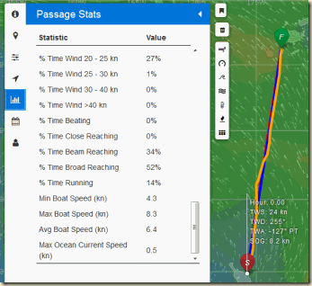
You can then look at the Stats about the calculated route: how many days, how many hours motoring, percentage of time beating/reaching/running, maximum wind speeds, minimum wind speeds, average boat speed, etc.
fastseas4
You can setup the polars for your boat describing how she points and what speed she does for various wind speeds and directions (or use the generic polar). This tab also lets you enter at what boat speed you will decide to motor and how fast you will motor.

fastseas3
One of the best features is the Departure Planning tab. It creates a route for the next ten days or so, assuming your original start date and time. You can then compare the Stats for each day and make a better decision on what day is the optimum departure date. For us we are trying to number one minimize the beating (sailing close to the wind, which is uncomfortable offshore) and number two to minimize motoring (hate that racket and dinosaur consumption).
currents
There are few things that I’d like to see improved on Fastseas, but Jeremy, the developer of Fastseas is pretty active doing updates and making sure the program scales to the number of users. He’s had to add a small fee for unlimited use (free to use multiple times per month and try out) to help cover the Amazon Web Services Cloud computing costs.
One item I don’t like is that Fastseas uses the current predictions in its optimization. While this sounds good in theory and probably works well say in the Atlantic where the Gulf Stream moves in a fairly consistent river of water. The image above is a display of the current predictions between New Zealand and Fiji. You probably can’t make it from the image but basically the currents are just all over the place. Being 20 miles west of your position might reverse the .5 kt current shown on the display. In practice these predictions are useless on this passage and just add error to the optimization. Fortunately its not much error because the currents are small and somewhat random.
Give FastSeas.com a try next time you are planning passage.
Paul

Tuesday, May 9, 2017

The Girls–Donna and Ella

17-nasaseestrop
This NASA picture of Cyclone Donna, on the left, and newly minted Cyclone Ella, on the right, has kinda put the kibosh on heading to Fiji – which is inconveniently located directly between the swirls in this picture. Donna is the strongest cyclone ever recorded in May in this area. While a cyclone can very occasionally happen in any month in the South Pacific, having two past the end of the season simultaneously is pretty rare. We really thought that this weekend would give us a window to get moving on the passage. But with Ella just getting going plus an unexpected Low showing up in the weather models in the Tasman next Tuesday it is looking more like we will be waiting in New Zealand for a while longer.

While I greatly appreciate you informing me, on three separate occasions, that I am not under investigation, I nevertheless concur with the judgment of the Department of Justice that you are not able to effectively lead the Bureau.
D. Trump
Sitting here on the boat gives me plenty of time to browse the news. I just caught the latest where Trump fired the FBI Director Comey. From his letter firing Comey (snippet above) it sounds like he is firing Comey because he knows that any director who does not investigate him must be tainted and incompetent.
Paul

Friday, May 5, 2017

Passage Weather

pressurre
We’re sitting in the Bay of Islands, New Zealand waiting to catch a weather window to make the thousand mile passage to Fiji. Above is a barometric pressure display courtesy of windy.com. A great site for visualizing the weather anywhere in the world.  You can see our new acquaintance Donna in the upper center of the map. She started out as a small closed low located between New Caledonia and Vanuatu. Small lows in the tropics are something to watch closely when leaving NZ – more on that latter in this blog.
pacific-polynesia-map-1000
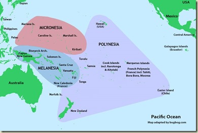
For those of you who don’t have a clue where New Caledonia and Vanuatu are, they are located near the bottom right of the area labeled Melanesia in the map above.
Now, that little low morphed into a deeper low over a few days and became Tropical Depression 21F. Not a very elegant name. Cyclone season is officially over at the end of April so at most 21F should have whipped up a little wind and waves and quickly dissipated. The whipped-up wind, however, managed to get strong enough to earn the title Cyclone Donna. Currently the winds are up to about 90-100kts and this earns her a Category 3 rating. The Cat ratings in the South Pacific are different than the Cat ratings used in the Atlantic hurricane season. Needless to say Cat 3 is significantly greater than breezy. Current predictions have her going South and then East. From there she will most likely become an extra-tropical low and connect with a frontal system that will lie between New Zealand and Fiji mid-next week.
My careful analysis of passage weather is that if there is a cyclone or something that begs to become a cyclone out there, then stay in port, no matter what the predicted track is. Most of the yachties planning to head to islands have also decided to wait out the situation. A few boats have left over last 2 or 3 days, mostly to Tonga. Not for me, I’ll ride on the chicken side. Cyclone rustling is not on my bucket list.
So back to the pressure map shown above. Donna is in the upper middle with some deep low pressure indicated by the purple. There are two large highs (orange/yellow) one over the Tasman Sea and New Zealand, the other over Australia. In between them in the Southern Ocean is a front with a low shown in blue.  Once Donna dissipates and heads a bit east the front that is in the Tasman should pass over NZ giving rain and northerly winds. As it passes by the winds will clock to SW and the high that is over Australia will move onto NZ. This should give us great boost all or most of the way to Fiji. Right now that looking like late Thursday or Friday (or maybe Saturday). Or maybe it will all change by then.
One of the nice features of windy.com is that you can click two different weather models. One is ECMWF, aka the Euro model, and GFS, aka the US model. When you look days into the future and the two models do not agree with each other, you can have high confidence that one or both is wrong. In other words the forecast isn’t good for much. If the two models converge onto predictions that are reasonably close then I have a lot more faith on them.
ramatha
Rescue of Ramtha by the HMSNZ Monowai. You can just see the bow of Ramtha in the left hand side and the crew being transferred toward the right in obviously horrendous conditions.
Back to why the small lows in the tropics are important to watch when leaving NZ.  In the first week of June, 1994 was the infamous Queen’s Birthday Storm. At least 8 boats were lost and three crew.
queensbirthday
Position of the Low and the yachts around it on June 4, 1994
A low moved across the path of the boats headed north. A large high was over the Tasman Sea and NZ.  This caused a compression zone between the high and the low. This is where the isobars (equal pressure lines) get pushed together causing a steep decline over a relatively short distance. The result of this was very high winds. The result of very high winds is very high seas. When this is bad enough it gets the name Weather Bomb.
We spend a lot of time digesting the weather sources before departure. This usually gets you a decent 2 to 3 days where you can be reasonably confident on what the conditions will be. After that you take what comes, making (hopefully minor) tactical course changes till your destination.
Paul