We’re sitting in the Bay of Islands, New Zealand waiting to catch a weather window to make the thousand mile passage to Fiji. Above is a barometric pressure display courtesy of windy.com. A great site for visualizing the weather anywhere in the world. You can see our new acquaintance Donna in the upper center of the map. She started out as a small closed low located between New Caledonia and Vanuatu. Small lows in the tropics are something to watch closely when leaving NZ – more on that latter in this blog.

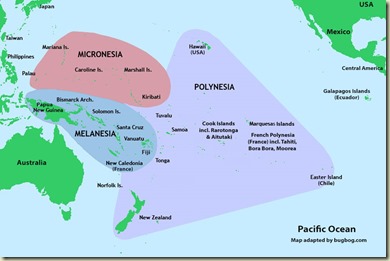
For those of you who don’t have a clue where New Caledonia and Vanuatu are, they are located near the bottom right of the area labeled Melanesia in the map above.
Now, that little low morphed into a deeper low over a few days and became Tropical Depression 21F. Not a very elegant name. Cyclone season is officially over at the end of April so at most 21F should have whipped up a little wind and waves and quickly dissipated. The whipped-up wind, however, managed to get strong enough to earn the title Cyclone Donna. Currently the winds are up to about 90-100kts and this earns her a Category 3 rating. The Cat ratings in the South Pacific are different than the Cat ratings used in the Atlantic hurricane season. Needless to say Cat 3 is significantly greater than breezy. Current predictions have her going South and then East. From there she will most likely become an extra-tropical low and connect with a frontal system that will lie between New Zealand and Fiji mid-next week.
My careful analysis of passage weather is that if there is a cyclone or something that begs to become a cyclone out there, then stay in port, no matter what the predicted track is. Most of the yachties planning to head to islands have also decided to wait out the situation. A few boats have left over last 2 or 3 days, mostly to Tonga. Not for me, I’ll ride on the chicken side. Cyclone rustling is not on my bucket list.
So back to the pressure map shown above. Donna is in the upper middle with some deep low pressure indicated by the purple. There are two large highs (orange/yellow) one over the Tasman Sea and New Zealand, the other over Australia. In between them in the Southern Ocean is a front with a low shown in blue. Once Donna dissipates and heads a bit east the front that is in the Tasman should pass over NZ giving rain and northerly winds. As it passes by the winds will clock to SW and the high that is over Australia will move onto NZ. This should give us great boost all or most of the way to Fiji. Right now that looking like late Thursday or Friday (or maybe Saturday). Or maybe it will all change by then.
One of the nice features of windy.com is that you can click two different weather models. One is ECMWF, aka the Euro model, and GFS, aka the US model. When you look days into the future and the two models do not agree with each other, you can have high confidence that one or both is wrong. In other words the forecast isn’t good for much. If the two models converge onto predictions that are reasonably close then I have a lot more faith on them.

Rescue of Ramtha by the HMSNZ Monowai. You can just see the bow of Ramtha in the left hand side and the crew being transferred toward the right in obviously horrendous conditions.
Back to why the small lows in the tropics are important to watch when leaving NZ. In the first week of June, 1994 was the infamous Queen’s Birthday Storm. At least 8 boats were lost and three crew.
Position of the Low and the yachts around it on June 4, 1994
A low moved across the path of the boats headed north. A large high was over the Tasman Sea and NZ. This caused a compression zone between the high and the low. This is where the isobars (equal pressure lines) get pushed together causing a steep decline over a relatively short distance. The result of this was very high winds. The result of very high winds is very high seas. When this is bad enough it gets the name Weather Bomb.We spend a lot of time digesting the weather sources before departure. This usually gets you a decent 2 to 3 days where you can be reasonably confident on what the conditions will be. After that you take what comes, making (hopefully minor) tactical course changes till your destination.
Paul


No comments:
Post a Comment