Time to fill in some pics of the 10 days we spent around Gulfo de Fonseca at the southern end of El Salvador. We went down to meet up with Pam and Henry who were traveling down on Rapscullion, Henry’s trick catamaran ride.
El Salvador requires that a boat receive a Zarpe (exit paperwork) even to travel to another port within the country. They make the paperwork very easy and convenient, but it is still an unneeded $40 expense. Next time, I think we’d just get a Zarpe for leaving the country and then go into the Golfo, but not go all the way into La Union, or any of the nearby commercial ports, to check out of the country.

To leave Bahia del Sol we had to head back out across the bar again. Rojelio, the bar pilot, had Tuesday off but he graciously agreed to come meet us 8:30am to guide us out at high tide. The surf wasn’t too bad, but you definitely do want a pilot here. You can see the bar, with breaking waves, in the distance.

The bar breaking on our way out
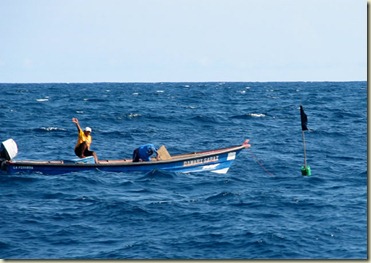
One of the panga (called lancha here) fisherman tied up to his little black flag 10 miles offshore. These are the flags that are supposed to warn you that their nets are out. If there’s a swell running they can be completely hidden behind the swells, as are the pangas themselves. And guess what, the black flag does not stand out at night. This guy is giving us the international hand signal for it appears if you stay on your present course you are not going to run over my net and foul it in your prop– but watch out for the next one.
Pam needed to check out the boat lift at the Naval yard in La Union to determine how well it would handle hauling her 46ft steel hull boat,
Precious Metal. The first few nights in the Gulf, we anchored in Tamarindo Bay just in front of where Giovanni- a real go-getter local who we first met at the lunch we had with the brass in San Salvador- plans to develop a new marina, the first in the Golfo de Fonseca. Giovanni picked us up one day and we visited his development site and then headed over to La Union.

The first pier and beach area for the new marina. This is going to be an ecologically sound development. They finally received their government approvals after two years of work. Interested in investing?
Giovanna on the left, John off Sea Quest in the middle, and yours truly looking at where the dredging spoils will go. John has developed and run major boat yards in California and Mexico and is interested in being involved in the development of a potential dry storage yard in La Union.
Giovanni drove us all up to the town of Chonchaguara(sp) in the hills just above La Union. The church above was originally built on one of the offshore islands. It was moved here in 1700’s (or so) brick by brick to make it more defensible– damn pirates. Gofo de Fonseca was long a haven for forays on the Spanish gold plunder from S. America.
When you head out with Giovanni (right), there always seems to be a good meal involved.


Here’s a couple of pictures of the unfortunate white elephant at La Union, a project not yet complete. This brand new container port was built by the Japanese a couple years ago, with promised French involvement. Those yellow container lifts are reportedly $10 million a piece. The plan was to build a new container port in La Union and connect it with an existing container port on the Caribbean side of Honduras by taking the old United Fruit Company narrow gauge railroad and rebuilding it into a double rail cross Central America track. This would then give an alternative to some of the container traffic that passes through the Panama Canal- a money maker to be sure. The Japanese built the port and dredged the entrance. The world market went to hell and the French pulled out before staring the rail line. Not a single container ship has landed here. This is just not the kind of infrastructure investment that El Salvador needs at this time. It’s too bad, because it seems like the government is really trying to fortify the country’s economy to create jobs for the locals and grow the middle class (and get re-elected). Unfortunately, many Salvadorans invested in businesses that would support the port and they are now hurting- badly.

We also got a good guided tour of the Naval Base. Here’s one of the ships having work done on the Naval boat yard lift. In order to lift Lovely Lady out of the water (for inspection and repairs after her grounding), this boat needed to be moved. The Commander at the base said that they could finish up work on this boat fairly quickly. But before they could put it back in the water- and haul the civilian sailboats- they would need to do some maintenance on the lift itself, which would take a little more time. Pam was glad to hear they were going to do the maintenance before Precious Metal would be hauled.
However, the maintenance didn’t go so well and the boat, and part of the pier, fell over during the attempted launching a few days later. Not sure when this will get fixed. Does not give you a warm and fuzzy about hauling your boat here at this time.
Isla Meanguera, Golfo de Fonseca
About 10 miles off La Union or Tamarindo is Isla Meanguera. We spent all total about 4 or 5 nights in the peaceful anchorage in the little bay where the La Joya de Golfo hotel is located. This is a four room hotel run by an ex-pat from LA and his El Salvadorian wife (also from LA). The Lonely Planet guide describes it: as a very nice place to stay, and that’s a good thing as it is the only place to stay on the island. The anchorage was nice, but the evening thunderstorms left a little to be desired in the ‘peaceful category’
La Joya de Golfo Hotel
Me and the hotel dog Gordo putting in some deck time
Chris and Rachel, the very talkative and fun hotel kid making sure George the hotel cat is comfortable.
Having a good-bye dinner on the deck at the hotel.

The island has some nice stone paved roads, but no cars. Here’s some of the goods transporters hanging by the docks.

There’s one pupuseria (pupusa – the Salvadoran stuffed thick tortilla) in the village on the island. Check the local green parrots (pets) up in the right side of the roof frame. These guys were just bored looking at us on a hot day until the proprietess came out to talk with them. Then they started singing, dancing and vying for her attention.
Then the boss parrot started tongue kissing with the proprietor
Pam saw a chance for some bird affection and gave it a try while Henry watched and wondered about why not me.
These guys are way cool.
End of photo update Uno.
Paul


 We are anchored off this beach in the cut between two islands in the Isla Murcielagos chain, the ranger’s station is on the island across the cut on the other side. Got in some good snorkeling on the north east side of this island and then Chris went in to the beach to compete with the hermit crabs for cool shells.


 Posts
Posts


